As communities in the central US grapple with widespread devastation from a line of deadly storms that spawned dozens of tornadoes this week, forecasters are warning of more grave threats to the region: additional severe thunderstorms and relentless rain with the potential to trigger “generational” flooding into the weekend.
At least eight people have been killed across Tennessee, Missouri, Indiana and Kentucky during extreme weather this week. The most recent death occurred Friday morning, when a young boy was swept away by floodwaters while walking to his school bus stop in Frankfort, Kentucky, police said.
The Mississippi Valley, including parts of Arkansas, Missouri, Tennessee and Mississippi, is in the midst of a three-day stretch of a level 4 of 4 high risk of flooding rain – an occurrence almost unheard-of outside hurricane season. The prolonged extreme flood threat adds another level of danger and misery for anyone picking up the pieces from extensive storm damage.
More than 200 flood warnings spanned at least 14 states Friday morning and those numbers will likely climb into the weekend.
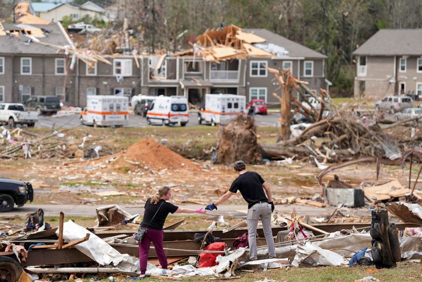
Selmer, Tennessee, a town about 90 miles east of Memphis, was hit hard in Wednesday’s tornado outbreak. Residents of a newly built apartment complex there scrambled to take shelter as the storm struck.
“Most people took shelter in their laundry rooms inside of the apartments,” said resident Justin West, whose unit survived while the front of the complex was “almost gone.”
West witnessed cars destroyed in the parking lot, piles of debris and sections of the roof torn away. The complex opened less than a year ago, he pointed out.
Tennessee Gov. Bill Lee urged residents to stay alert, saying, “Don’t let your guard down.”
“There’s been a lot of damage, there’s been a lot of tornadoes, there’s been loss of life and real devastation across the state, but this storm is going to continue,” Lee said on Thursday.
At least five deaths had been reported in the state, according to Patrick Sheehan, director of the Tennessee Emergency Management Agency. And there were more than 3,000 customers without power in the state early Friday, according to PowerOutage.us.
At one point Thursday, tornado sirens in Nashville were sounding so frequently, their batteries drained and they fell silent, remaining inoperable until power was restored, city emergency officials said, encouraging residents to have multiple ways to receive weather alerts, including local news, weather apps and weather radios.
In Pilot Grove, Missouri, a tornado swept through the small city, leaving a trail of scattered debris, CNN affiliate KOMU reported. Among those affected was Justin Gerke, who rushed home after receiving an alert.
“I got a tornado warning alert on my phone and came home as soon as I could from work,” Gerke told KOMU. When he arrived, he found the roof of his childhood home ripped off, the garage obliterated, and several destroyed cars.
In Nevada, Missouri, the storm left widespread damage, including at Nevada Oaks, a former motel now serving as student housing for the Missouri Welding Institute, a trade school specializing in welding and metal fabrication. The family-owned property, which houses approximately 50 students, sustained significant damage, residents told CNN affiliate KSHB.
“This is our heart and soul,” Shari Snyder, who operates Nevada Oaks, told KSHB. “We love this place, my dad put everything into this place, and the students loved it here.” While no students were injured in the storm, the tornado shattered windows and destroyed several cars in the parking lot, the affiliate reported.

Damage survey teams from the National Weather Service have given preliminary ratings to at least 27 tornadoes in eight states since the outbreak began Wednesday.
So far, they have found three tornadoes of at least EF3 strength in Missouri, Tennessee and Arkansas. Additional surveys could take days to complete and some have been held up by the continuing hazardous weather.
More life-threatening flooding and severe thunderstorms to come
As the cleanup of tornado damage begins, the persistent threat of flooding and a renewed risk for damaging thunderstorms looms large.
A “life-threatening, catastrophic, and potentially historic flash flood event continues across the Lower Ohio Valley and Mid-South to Lower Mississippi Valley,” the Weather Prediction Center warned Friday.
A level 4 of 4 high risk of flooding rainfall is in place Friday and Saturday, with the greatest impact going forward expected from far northeastern Texas to Kentucky.
From Arkansas to Kentucky, historic rainfall could bring once-in-a-generation flooding, with more than a foot of rain falling on the area in just a few days.
Flooding is already underway and will likely worsen after some areas recorded more than 6 inches of rain Wednesday through Thursday. Rainfall totals are projected to be so extreme that forecasters are using statistical terms, such as 1-in-25-year, 1-in-100-year, and even 1-in-1000-year events, to describe their rarity.
Climate change is making heavy rainfall events heavier. A recent study found hourly rainfall rates have intensified in nearly 90% of large US cities since 1970.
A serious storm threat is developing Friday in tandem with the flood threat. A level 4 of 5 risk of severe thunderstorms is in place from northeastern Texas, through Arkansas and into southern Missouri, according to the Storm Prediction Center.
The fiercest storms will start to fire up later Friday afternoon and will continue through the evening. These storms could unleash damaging winds, large hail and tornadoes – some of which could be rated EF2, EF3 or higher, according to the center.
Ahead of the worsening flooding and new storms, federal and local agencies have mobilized water rescue teams and emergency supplies, including food and water, to brace for the worst.
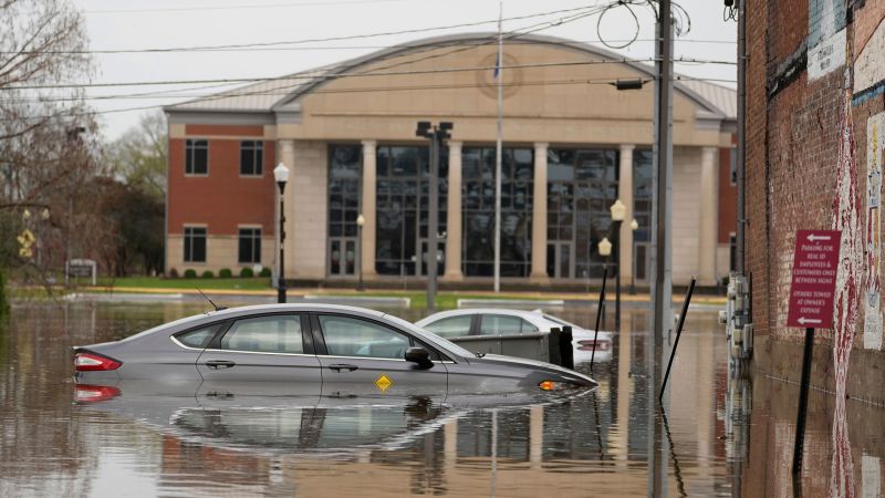
In Nashville, over a dozen water rescues took place on Thursday as relentless rain battered the city. Near Trevecca Nazarene University, first responders pulled a driver from a partially submerged vehicle, guiding him through a window and onto a rescue raft.
Officials in Tennessee and Kentucky announced schools in several districts would remain closed on Friday, including Allen County Schools and Davidson Academy.
In Missouri, the Army Corps of Engineers said it had filled roughly 1,500 sandbags to bolster a levee near Poplar Bluff, where the Black River is projected to approach a level of “major flooding” category over the weekend. An urban search-and-rescue team has also been deployed to the area to support emergency efforts.
Shipping delays are also possible with the major cargo hubs of Louisville, Kentucky, and Memphis, Tennessee, in the line of storms.
In Kentucky, Gov. Andy Beshear declared a state of emergency for the western part of the state, warning of record rainfall in areas unaccustomed to flooding. At least 25 state highways, primarily in the west, were submerged by floodwaters Thursday, according to the governor’s office. This comes after other recent flooding events in Kentucky. In February, a deadly winter storm claimed several lives, and in 2021, the state faced another large-scale flash-flooding disaster.
Correction: A previous version of this story incorrectly stated the number of storm-related deaths in McNairy County, Tennessee. As of Friday morning, one death has been confirmed in the county, the state’s emergency management agency said.

